Difference between revisions of "Inclinometers"
(Created page with "Category:Meters, Gauges{{Knoppen}} <noinclude><!------------------------------------------------ * READ THIS FIRST * Only edit this page if you can improve the content. ...") |
|||
| Line 7: | Line 7: | ||
* Please start editing this page after the /noinclude | * Please start editing this page after the /noinclude | ||
* -------------------------------------------------></noinclude> | * -------------------------------------------------></noinclude> | ||
[[File:Inclinometers.jpg|thumb|right|Inclinometers]] | |||
[[File:Inclinometer1.jpg|thumb|right|Inclinometers]] | |||
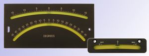
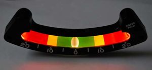
'''Inclinometer''' or clinometer is an instrument for measuring angles of slope , elevation or depression of an object with respect to gravity. These are also known as tilt meters, tilt indicators, slope alerts, slope gauges, gradient meters, gradiometers, level gauges, [[Level Meters]], declinometers, and pitch & roll indicators. Clinometers measure both inclines and declines using three different units of measure: degrees, percent, and topo. Astrolabes are inclinometers that were used for navigation and locating astronomical objects. | |||
In aircraft, the ball in turn coordinators or turn and bank indicators is sometimes referred to as an inclinometer. | |||
==Use== | |||
A forester using a clinometer makes use of basic trigonometry. First the observer measures a straight-line distance D from some observation point O to the object. Then, using the clinometer, the observer measures the angle a between O and the top of the object. Then the observer does the same for the angle b between O and the bottom of the object. Multiplying D by the tangent of a gives the height of the object above the observer, and by the tangent of b the depth of the object below the observer. Adding the two of course gives the total height (H) of the object. | |||
The forester stands at a fixed distance from the base of the tree. The most common distances in the United States are 50 feet (15.24 m), 66 feet (20.12 m), and 100 feet (30.48 m).To obtain accurate readings it is best to use taped measured distance instead of paced distances. For the most accurate readings it is best to use a distance that is not less than the height of the tree being measured.,that is, that the clinometer will measure an angle less than 45° (100%). | |||
The observer sights to the top of tree, if total height is the desired measurement. If the desired measurement is merchantable height – that is, the height producing timber that can be sold – the observer sights to a point on the tree above which no more merchantable timber is found. Note that the observer should use slopes expressed as a percent. The observer then measures to the bottom of the tree, again using percents. The observer than takes the slope to the top of the tree, and subtracts the slope of the bottom of the tree from it. Note that when the ground slopes downwards, the observer will record a negative slope to the base of the tree. When this is subtracted from the slope to the top of the tree, it is actually being added. These numbers are then divided by 100, and multiplied by the distance from the tree. | |||
There is still some error in this number, because the distance is measured along the ground, and is not the actual horizontal distance. By standing at the base of the tree, the observer should mark his/her eye level. They then stand back, and find the slope expressed as a degree to the mark. This is the slope of the ground. By taking the cosine of that number, and multiplying it with the previous number, the observer will calculate the height of the tree.The observer must always measure a leaning tree so that the tree is leaning to the left or right. Measurements should never be taken with the tree leaning toward or away from the observer because this will affect their accuracy because of foreshortening. | |||
The clinometer is also commonly used by foresters to obtain the percent slope of terrain. This measurement is based on the same trigonometric principles described above. Slope measurements, however, require that both observer and target be a constant height above the ground; thus a range pole or height of measurement (HI) stick is often used in slope measurements. | |||
==Accuracy== | |||
Certain highly sensitive electronic inclinometer sensors can achieve an output resolution to 0.0001 degrees - depending on the technology and angle range, it may be limited to 0.01º. An inclinometer sensor's true or absolute accuracy, however, is a combination of initial sets of sensor zero offset and sensitivity, sensor linearity, hysteresis, repeatability, and the temperature drifts of zero and sensitivity - electronic inclinometers accuracy can typically range from .01º to ±2º depending on the sensor and situation. Typically in room ambient conditions the accuracy is limited to the sensor linearity specification. | |||
==Sources== | |||
[http://en.wikipedia.org/wiki/Inclinometer Wikipedia Inclinometer] | |||
Latest revision as of 10:53, 28 December 2012
Inclinometer or clinometer is an instrument for measuring angles of slope , elevation or depression of an object with respect to gravity. These are also known as tilt meters, tilt indicators, slope alerts, slope gauges, gradient meters, gradiometers, level gauges, Level Meters, declinometers, and pitch & roll indicators. Clinometers measure both inclines and declines using three different units of measure: degrees, percent, and topo. Astrolabes are inclinometers that were used for navigation and locating astronomical objects. In aircraft, the ball in turn coordinators or turn and bank indicators is sometimes referred to as an inclinometer.
Use
A forester using a clinometer makes use of basic trigonometry. First the observer measures a straight-line distance D from some observation point O to the object. Then, using the clinometer, the observer measures the angle a between O and the top of the object. Then the observer does the same for the angle b between O and the bottom of the object. Multiplying D by the tangent of a gives the height of the object above the observer, and by the tangent of b the depth of the object below the observer. Adding the two of course gives the total height (H) of the object.
The forester stands at a fixed distance from the base of the tree. The most common distances in the United States are 50 feet (15.24 m), 66 feet (20.12 m), and 100 feet (30.48 m).To obtain accurate readings it is best to use taped measured distance instead of paced distances. For the most accurate readings it is best to use a distance that is not less than the height of the tree being measured.,that is, that the clinometer will measure an angle less than 45° (100%).
The observer sights to the top of tree, if total height is the desired measurement. If the desired measurement is merchantable height – that is, the height producing timber that can be sold – the observer sights to a point on the tree above which no more merchantable timber is found. Note that the observer should use slopes expressed as a percent. The observer then measures to the bottom of the tree, again using percents. The observer than takes the slope to the top of the tree, and subtracts the slope of the bottom of the tree from it. Note that when the ground slopes downwards, the observer will record a negative slope to the base of the tree. When this is subtracted from the slope to the top of the tree, it is actually being added. These numbers are then divided by 100, and multiplied by the distance from the tree.
There is still some error in this number, because the distance is measured along the ground, and is not the actual horizontal distance. By standing at the base of the tree, the observer should mark his/her eye level. They then stand back, and find the slope expressed as a degree to the mark. This is the slope of the ground. By taking the cosine of that number, and multiplying it with the previous number, the observer will calculate the height of the tree.The observer must always measure a leaning tree so that the tree is leaning to the left or right. Measurements should never be taken with the tree leaning toward or away from the observer because this will affect their accuracy because of foreshortening.
The clinometer is also commonly used by foresters to obtain the percent slope of terrain. This measurement is based on the same trigonometric principles described above. Slope measurements, however, require that both observer and target be a constant height above the ground; thus a range pole or height of measurement (HI) stick is often used in slope measurements.
Accuracy
Certain highly sensitive electronic inclinometer sensors can achieve an output resolution to 0.0001 degrees - depending on the technology and angle range, it may be limited to 0.01º. An inclinometer sensor's true or absolute accuracy, however, is a combination of initial sets of sensor zero offset and sensitivity, sensor linearity, hysteresis, repeatability, and the temperature drifts of zero and sensitivity - electronic inclinometers accuracy can typically range from .01º to ±2º depending on the sensor and situation. Typically in room ambient conditions the accuracy is limited to the sensor linearity specification.

